PLEASE BE ADVISED: Due to unprecedented tariffs on goods from China, a fee to help offset a portion of the import costs is now being added at checkout. Questions? Please call.

DJI Matrice 400

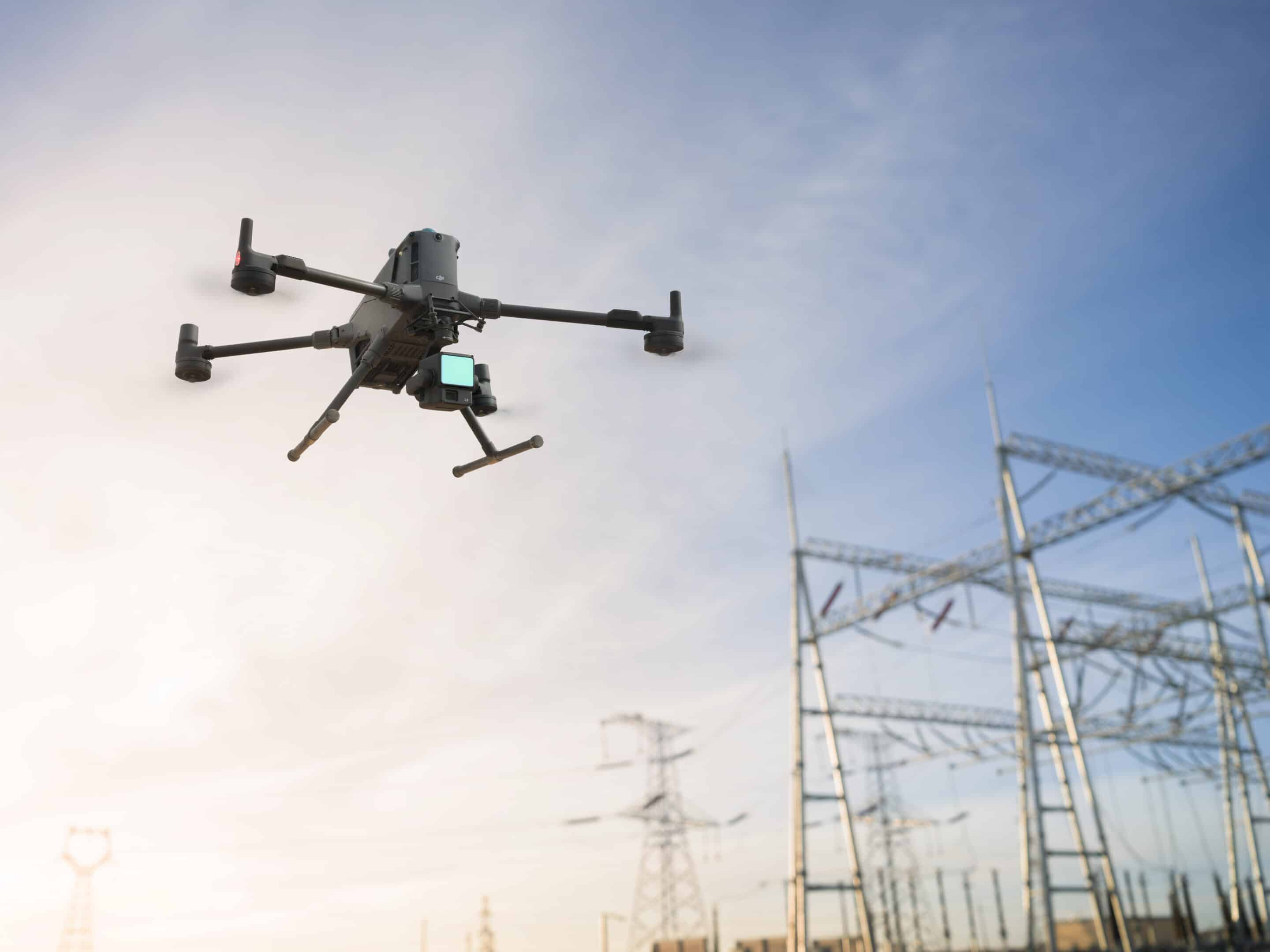
The DJI Matrice 400 is a powerhouse in the drone world, designed to handle tough jobs with ease. It offers a whopping 59 minutes of flight time, so you can stay in the air longer without worrying about battery swaps. With a strong payload capacity of up to 13.2 pounds, it can carry a variety of cameras and sensors, making it perfect for everything from inspections and mapping to search and rescue missions. Plus, it features advanced obstacle sensing with LiDAR and mmWave radar, so it flies safely even in complex environments.

What really sets the Matrice 400 apart is its smart technology and versatility. It supports enhanced video transmission and relay systems, meaning you get clear, reliable feeds no matter where you’re flying. The drone’s built-in automation and AR projection capabilities make complex operations simpler, whether you’re working on power lines, conducting emergency response, or handling construction projects. Basically, it’s a rugged, reliable workhorse that’s ready to take your aerial missions to the next level.

$10,450.00

Drone Highlights

Up to 13lbs Payload Capacity
Comprehensive Accessory Upgrades
Multi-Payload, Multi-Scene

Featured Specs

The DJI Matrice 400 is built for serious performance, offering up to 59 minutes of flight time on a single battery charge. It can carry payloads weighing up to 13.2 pounds, allowing it to handle a wide range of professional cameras and sensors. The drone features an integrated rotating LiDAR and mmWave radar system for precise obstacle sensing, providing enhanced safety and navigation in complex environments. Its maximum takeoff weight is around 3.3 pounds heavier than the payload capacity, giving it the strength to handle demanding industrial tasks.

On the technical side, the Matrice 400 supports the O4 Enterprise Enhanced Video Transmission system, delivering high-quality, low-latency video up to several miles away. It also offers Airborne Relay Video Transmission for extended range and reliability. The drone has a max horizontal speed of about 47 mph and can operate in temperatures ranging from 14°F to 104°F. Its smart features include visible and thermal imaging, AR projection, and automated flight controls, making it a versatile tool for inspections, emergency response, mapping, and construction applications.

Maximum payload capacity
Up to 13.2 pounds
Maximum hover duration
Up to 53 minutes
Forward flight time
Up to 59 minutes
Horizontal flight speed
Up to 47mph
Operating temparature
14° to 104° F

Drone Specs

Aircraft

Takeoff Weight (with propellers)

Without Batteries: 11 lbs
With Batteries: 21.5 lbs

The actual product weight may vary due to differences in batch materials and external factors.

Max Takeoff Weight

34.8 lbs

Dimensions

Unfolded: 3.2×2.5×1.6 ft (L×W×H) (with landing gear)
Folded: 1.6×1.6×1.6 ft (L×W×H) (with landing gear and gimbal)

Maximum dimensions excluding propellers.

Aircraft carrying case dimensions: 2.6×1.2×1.7 ft (L×W×H)

Max Payload

13 lbs

The 13 lbs payload is measured at the third gimbal connector under sea level conditions. Payload capacity decreases as altitude increases. For details, refer to the official user manual.

Propeller Size

25 inches

Diagonal Wheelbase

3.5 ft

Max Ascent Speed

33 ft/s

Max Descent Speed

26 ft/s

Max Horizontal Speed (at sea level, no wind)

82 ft/s

Max Takeoff Altitude

22,966 ft

Max Flight Time (no wind)

59 minutes

Measured with the aircraft flying forward at a constant speed of 33 ft/s in a windless environment at sea level, carrying only the H30T (total weight 23.5 lbs), and from 100% battery level until 0%. Data is for reference only. Actual experience may vary depending on the environment, usage, and firmware version.

Max Hover Time (no wind)

53 minutes

Measured with the aircraft hovering in a windless environment at sea level, carrying only the H30T (total weight 23.5 lbs), and from 100% battery level until 0%. Data is for reference only. Actual usage time may vary depending on the flight mode, accessories, and environment.

Max Flight Distance (no wind)

30.4 mi

Measured by the aircraft flying forward at a constant speed of 55 ft/s in a windless environment at sea level, without external payloads, and from 100% battery level until 0%. Actual experience may vary depending on the environment, usage, and firmware version.

Max Wind Speed Resistance

39 ft/s

Max wind speed resistance during takeoff and landing.

Max Yaw Angular Velocity

Yaw: 100°/s

Max Pitch Angle

35°

Operating Temperature

4° to 122° F (without solar radiation)

Global Navigation Satellite System (GNSS)

GPS + Galileo + BeiDou + GLONASS*

* GLONASS is supported only when the RTK module is enabled.

Equipped with standard airborne ADS-B In receiver and dual antennas, supporting reception up to 12.4 miles.

Hovering Accuracy Range (with moderate or no wind)

Vertical:
±0.33 ft (with vision positioning)
±1.6 ft (with satellite positioning)
±0.33 ft (with RTK positioning)

Horizontal:
±0.99 ft (with vision positioning)
±1.6 ft (with satellite positioning)
±0.33 m (with RTK positioning)

RTK GNSS Accuracy

RTK Fix:
1 cm + 1 ppm (horizontal), 1.5 cm + 1 ppm (vertical)

RTK Heading

Supports RTK heading with an accuracy better than 2°

Airborne ADS-B In

Equipped with standard airborne ADS-B In receiver and dual antennas, supporting reception up to 12 miles.

Internal Storage

N/A

Ports

USB-C Debug Port × 1: USB 2.0
E-Port V2 × 4: At the lower part of the drone, with 120W single-port power
Cellular Dongle 2 Interface × 2: On the underside of the drone

Propeller Model

2510F

Beacon

Built into the aircraft

Ingress Protection Rating

IP55

The rating is not permanently effective and may decrease due to product wear and tear.

Gimbal

Maximum Payload for Single Gimbal Connector

3.1 lbs

If exceeds, the gimbal damper lifespan will decrease from 1000 hours to 400 hours.

Maximum Payload for Dual Gimbal Connector

2.1 lbs

Maximum Payload for Third Gimbal Connector

6.6 lbs for quick-release port, 13 lbs for screw lock fastening

Sensing

Sensing Type

Omnidirectional binocular vision system (surround view provided by full-color fisheye vision sensors)

Horizontal rotating LiDAR, upper LiDAR and downward 3D infrared range sensor

Six-direction mmWave radar

Forward

Measurement Range: 1.3-39 ft
Detection Range: 1.3-656 ft
Field of View (FOV): 90° (horizontal), 90° (vertical)

Backward

Measurement Range: 1.3-69 ft
Detection Range: 1.3-656 ft
Field of View (FOV): 90° (horizontal), 90° (vertical)

Lateral

Measurement Range: 2-69 ft
Detection Range: 1.6-656 ft
Field of View (FOV): 90° (horizontal), 90° (vertical)

Downward

Measurement Range: 1.6-62 ft
The FOV to the front and rear is 160° and 105° to the right and left.

Operating Environment

Forward, Backward, Left, Right, and Upward:
Delicate texture on the surface, adequate light.

Downward:
The ground has rich textures and sufficient lighting conditions*, with a diffuse reflection surface and a reflectivity greater than 20% (such as walls, trees, people, etc.).

* Sufficient lighting conditions refer to an illuminance not lower than that of a nighttime city light scene.

Rotating LiDAR

Standard Measurement Range: 1.6-328 ft @ 100,000 lux with 10% reflectivity target
Measurement Range for Power Line: 114.8 m @ 30° @ 10,000 lux for 21.6 mm steel-core aluminum stranded wire with a relative body tilt angle of 30° to the left and right
Field of View (FOV): 360° (horizontal), 58° (vertical)
Point-Frequency: 520,000 points/second
Laser Wavelength: 905 nm
Eye Safety Level: Class 1 (IEC60825-1:2014), eye-safe

Upper LiDAR (3D ToF)

1.6-82 gy at night (reflectivity > 10%)
The FOV to the up and down is 60° and 60° to the right and left.

Downward 3D Infrared Range Sensor

Measurement Range: 1-26 ft (reflectivity > 10%)
The FOV to the front and rear is 60° and 60° to the right and left.

mmWave Radar

Measurement Range for Power Line:
118 ft for a 12.5mm steel-core aluminum stranded wire
164 ft for a 21.6mm steel-core aluminum stranded wire
FOV: ± 45° (horizontal and vertical)

The mmWave radar function is unavailable in some countries/regions.

FPV Camera

Resolution

1080p

Field of View (FOV)

DFOV: 150°
HFOV: 139.6°
VFOV: 95.3°

Frame Rate

30fps

Night Vision

Starlight Grade

Video Transmission

Video Transmission System

DJI O4 Enterprise Enhanced Video Transmission System

Live View Quality

Remote Controller: 3-channel 1080p/30fps

Operating Frequency and Transmitter Power (EIRP)

902-928 MHz: < 30 dBm (FCC), < 16 dBm (MIC)
1.430-1.444 GHz: < 35 dBm (SRRC)
2.4000-2.4835 GHz: < 33 dBm (FCC), < 20 dBm (CE/SRRC/MIC)
5.150-5.250 GHz: < 23 dBm (FCC/CE)
5.725-5.850 GHz: < 33 dBm (FCC), < 14 dBm (CE), < 30 dBm (SRRC)

Operating frequency allowed varies among countries and regions. Refer to local laws and regulations for more information.

Max Transmission Distance (unobstructed, free of interference)

24.8 mi (FCC)
12.4 mi (CE/SRRC/MIC)

Measured in an unobstructed environment free of interference. The above data shows the farthest communication range for one-way, non-return flights under each standard. During your flight, please pay attention to RTH reminder on the DJI Pilot 2 app.

Max Transmission Distance (with interference)

Strong interference (dense buildings, residential areas, etc.): approx. 1-3.7 mi
Medium interference (suburban counties, city parks, etc.): approx. 3.7-9 km
Weak interference (open spaces, remote areas, etc.): approx. 9-24.8 km

Data is tested under FCC standard in unobstructed environments of typical interference. Only to serve as a reference and provides no guarantee as to the actual flight distance.

Max Download Speed

Standard Mode: 80Mbps Downlink
Playback Download: < 25 MBps
Single-Channel Bitrate: ≤ 12 Mbps

The above data was measured under conditions where the aircraft and remote controller were in close proximity without interference.

Antenna

WLAN Antenna × 8: 6 vertically polarized antennas and 2 horizontally polarized antennas
sub2G Antenna × 2: 2 vertically polarized antennas
4G Antenna × 4

Operating Mode: 2T4R

Others

Supports Dual Control Mode and 2-channel Cellular Dongle 2

Battery

Model

TB100

Capacity

20254 mAh

Standard Voltage

48.23 V

Max Charging Voltage

54.6 V

Cell Type

Li-ion 13S

Energy

977 Wh

Weight

10.4 lbs

Charging Temperature

41° to 113° F

Discharging Temperature

-4° to 122° F

Battery Heating

Single Battery: Support
Onboard: Support
Battery Station: Support

Discharge Rate

4C

Max Charging Power

2C

Low-Temperature Charging

Supports low-temperature self-heating charging

Cycle Count

400